Category: Dwarka

Popular Myths

Dwarka Nagari – Popular Myths

(1) Dwarka was considered as Capital at Shree Krishna hile Bet Dwarka as residence. Shree Krishna used to conduct his religious assembly at Dwarka.

(2) Gopi Lake is located 14 kms. A way from Dwarka. Soil of Gopi talav is yellow in color while it is extremely smooth. There is myth that after leaving ‘ Vruj’ , Krishna never gone back to ‘Vruj’. During Krishna’s Childhood, he played ras leelas many times with gopies (young female inhabitant of Vruj). They traveled from ‘Vruj’ to Dwarka, to meet Shree Krishna. They after playing Ras Leelas again with Shree Krishna, on night of ‘Sharad Purnima’, they offered their lives to soil of this land and hence this land has become popular as ‘Gopi Talav’.

(3) Rukhmini Temple (Temple one of Shree Krishna’s Patranis), is located 2 kms a away from Dwarka There is a myth associated with it once Krishna and Rukhmini went to ‘Durvasha rushi’ to invite him at Dwarka. He was agreed on the condition that they (Krishna & Rukhmini) have to carry the chariot instead of any animal. Krishna & Rukhmini happily agreed to do so. While driving the chariot, Rukhmini became thirsty. Then Krishna stopped the chariot and made water of Holy River Ganga. ‘Durvasha’ annoyed by the action and curse Rukhmini to stay away from Shree Krishna Hence Rukhmini temple is located 2 kms. Away from Dwarka’s Jagat Mandir.

Airlift technique was adopted for digging within the caisson to dig trenches on the sides of structures. All drawings were prepared underwater.

Submerged Dwarka

The holy town of Dwarka (Lat.22’15’N Long. 69’E) in Jamnagar district of Gujarat State is believed to be the legendary city of Dwarka built by Lord Sri Krishna between 3500 and 5000 years ago. According to the epic Mahabharata the city in due course was submerged by the sea’. The Harivansh, an appendix to the Mahabharata says that Dwarka was situated on the bank of the river Gomati where it joins the western sea. The submergence of Dwarka and the cause of submergence are of historical and oceanographic interest because of historic Dwarka is likely to throw light on the Dark Age of Indian history.

The seven-storeyed temple of Dwarkadhish or Ranchodji at Dwarka rises to a height of 43 m at the confluence of the river Gomati with the Arabian Sea. The inner temple is assign- able to the 13th century AD and the subsequent enlargement in the form of an assembly hall known, as Ladwa mandap and the awe-inspiring sikhara are datable to the 15th century. There are some early temples on the bank of the Gomati river.

Within the enclosure of the Dwarkadhish temple complex shrines dedicated to Pradyumnaji, Devakiji, Purushottamji, Kuseshvar Mahadev and also the Sharda Peeth established by Adi Shankra Charya in the 9th century can be seen. A hundred years ago large boats could reach the Gomati ghat but the stonewall built by the erstwhile Gyakwad State in 1890 narrowed its mouth. A sand bar has now stopped the discharge of Gomati waters into the sea. The temple of Sea God or Samudra narayana, also known as Varun Devta or Chakra Narayan, which is situated near the ancient harbor at the western extremity of, is an important landmark from the point of view of archeological investigations.

The occurrence of a distinct ceramic ware known as the Red Polished Ware in layer 8 and the Lustrous Red Ware in layers 10 and 10A clearly distinguishes the early historic deposit from the Past and Historic. Layer 9 is yellowish sand and layer 10 is grayish silt, while layer 10A is pinkish sand and layer 11 almost the same without any artifact. The stemmed bowl and a miniature bowl of averted rim found in Dwarka excavation are comparable in form, fabric and treatment to those from Rangpur III. The excavation in 1979-80 pushed back the antiquity of Dwarka from 15th century AD to 15th century ‘BC and suggested the destruction of a coastal settlement by sea about 3500 years ago.

In all, eight settlements can be distinguished at Dwarka (IAR 1979-80, 22 ff). The first settlement made in the 15th century BC was submerged or washed away and so also the second one made in the 10th century BC. After a long gap the third settlement was made in the 1st century BC/AD as suggested by the Red Polished Ware and copper coins known as Kansha Varna It is during this phase that Temple I was built. The lime-plastered surface of its stone masonry still retaining a few lines of red ochre painting suggests that the plinth was open to view above the then working level. After the sea destroyed the first temple the second temple came to be built on the ruins of the first. When the second temple was also destroyed, the third temple dedicated to Vishnu or Vasudeva was built in the 9th century. It was perhaps in the 12th century a storm-wave blew away the roof leaving only the walls and plinth.

The Third Expedition exposed structures SE of DWK-SN transit line at four locations 200 to 700 m seaward of Samudra Narayan temple by removing the vegetation and sediment.’ It is observed that large well- dressed blocks of limestone (1.5 X 1 X 0.5 and 1 X 0.75 X 0.3m) used in construction have been partly disturbed but the plinths of some of the structures are in tact. For purposes of convenience the structural remains are designated ‘A’ through ‘D’. Structure ‘A’ near buoys 12 – 13 is the nearest to Samudra Narayan and ‘D’ the farthest near buoys 26 – 27. Structure A has two arms. It is difficult to say whether these structural remains form part of a single large building. But the crescents plan and the recovery of two moonstones (candrasila) from the neighborhood suggest the existence of a temple, for candrasila is the first step at the entrance to a temple. One of them has a wedge-shaped slit on the margin for joining.

The fourth temple came into existence soon after. The present temple of Dwarkadhish is the fifth in the series. Temples I to V represent respectively settlements III to VII and the modern town is the eighth settlement at Dwarka.

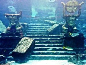
The Fourth Expedition in April 1986 found that the top stones of the masonry of the structures were disturbed by current and swell. In fact they lay under a thick mantle of sediment held by vegetation. The overburden was removed and trenches were dug on either side to expose at least a couple of courses of masonry. The Fourth Expedition, though of very short duration, could discover four 3-holed stone anchors of the type found in Syria and Cyprus and used during the 14th – 12th century BC. A large one is damaged but it was retrieved carefully. As the sea became very rough by the end of December the Expedition had to leave hurriedly. The experience of working in different months from October to May in four expeditions has shown that the proper season for exploration is from mid-November to mid-February even though in November and December heavy snow fall in Kashmir brings severe cold wind to Kachchh- Saurashtra and the sea becomes suddenly choppy. For instance, on 13th December 1986 the sea became so rough that waves 5 to 6 m high were breaking 200 m from shore, In the Third and Fourth Expeditions probing with an iron rod indicated locations of structures in the sea and vegetation was removed. The Fifth Expedition was highly successful in uncovering a massive bastion and fort walls besides three other structures — all in situ . Hundreds of architectural members are lying loose in the seabed within 800 m of SN temple. Five structures in situ were uncovered after removing vegetation and sand overlying the structures with an airlift or air jet. In several places small trenches had to be dug along the margin of structures with an air jet to trace a few courses of the masonry.

When Indra came to know that nobody worshipped him, he got very angry with Nandababa and cowherds. Stung by this insult Indra ordered the rain-God to invade Vraj. The whole Vraj was reeling under the impact of torrential rain. Dazed at this sudden calamity the people sought Shri Krishna’s help. To protect his devotees, Shri Krishna lifted the Govardhan on the tip of his little finger. For seven days, Shri Krishna held the Govardhan thus forgetting food and water. Shri Krishna’s YogMaya dazzled everybody, including Indra. The rain stopped and everybody was free from anxiety.

There is always the possibility of dislodging stones from the masonry if the sediments sealing the structures or acting as buttress on sides are removed in excavation. To avoid damage to structures due to strong current and swell, lower courses were not exposed. What is significant in the case of structures exposed beyond 600 m seaward of SN temple is that the building blocks of prismatic shape in situ give at least a partial plan of the structures. For instance, among the structural remains of Period I (Past and Historic) in the lower levels the bastion, fort wall and the corner of a rectangular building could be identified. It was not possible to reach the foundation of these structures, but it appears from the scoured plinth of the bastion, the builders heaped up boulders in seabed to build a wall or pier in coursed rubble masonry. The bastion and fort wall are fairly in tact up to 3 courses, but the maximum length traced is about 6 m in a couple of instances and less in others. The following structures are significant from the point of view of their utility, plan and chronology.

In order to ascertain the cultural sequence and to expose at least a couple of courses of masonry 14 small trenches were dug near the structures. Trench 10 dug near buoy 39 may be taken as representative of the stratigraphy of other trenches. Layer 1, 0.3 m thick, consists of fine sand, layer 2, 0.7 m thick, is composed of shingle and layer 3, 0.5 m thick, contains dead coral sand and shells; layer 4 about 1 m thick, is also sand in which a char blade has been found.

Airlift technique was adopted for digging within the caisson to dig trenches on the sides of structures. All drawings were prepared underwater.

Little History

Dwarka Nagari – Little History


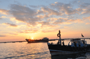
According to Hindu tradition still extant, the earliest known conqueror of Okhamandal was Shri Krishna, called also Ranchodji, the eight incaranation of Vishnu, Who after his seventeenth battle with Jara Sangh, king of Magadh Desh, fled from Mathura, and eventually arrived with his army at Okhamandal which he subjected after a hard struggle with the Kalas. Shri Krishna established his capital at Dwarka on the bank of the Gomti Creek.

Krishna was succeeded by the great grandson of Vajranabh, who enjoys the saintly reputation of having built the present temple Dwarkanath, called also Trilok sundar, signifying ‘the handsomest of the three world’ Many Hindus religiously believe that the temple was erected in one night by supernatural agency, under Vajranabh’s direction.

Certain it is that whole of western and south-western Saurashtra, now included in a Jamnagar and Junaghadh districts was colonized by the Yadavas, whose most important leader was Shri Krishna. The Yadavas ruled and when they perished in a family quarrel under the influence of drink, and after Shri Krishna’s death Dwarka submerged under the sea. In this region the original in habitants are said to Kabas, Modas and Kalas, The Kabas and Modas now seem to be extinct but the present day Vaghers are said to have descended from the Kabas.

The Kalas re-conquered Okhamandal in the 2nd Century A.D next a Syrian Sukkur Belium conquered this region and during this time Dwarka submerged by the sea. He was driven out by another Syrian named Mehem Guduka. Again Kalas now know as Vaghers.

It was 13th century when the Rathods came and took advantage of the Herule-chavada quarrels. The few surviving chavadas and Herules were absorbed by the Vaghers. Veravalji, the Rathod now became the sole ruler of Okhamandal. During the periods of Bhimji, Mahmud Begada who was sultan of Gujarat, conquered Okhamandal destroying the temple at Dwarka. Later the Vaghers drove out the Muslim.

The history of Okhamandal upto 1800 seems to be uneventful but since this date, until their final extermination or submission the Vadhelas and Vaghers came up repetedly against to the British and the Gaikwads.

1807 A.D.


Col. Walker was ordered to proceed to Okhamandal, imposed fine Rs.110000.

1816 A.D.


Col. East, reduced fine restored the District to the Gaikwads.

1845-47A.D.


Rebellions broke out at least twice because the Gaikwad administration was weak.British The deputed Lient Barton for the settlement.*

1868 A.D


The Vaghers convinced by time under the Gaikwads, Okhamandal formed a part of Amreli district.

1947 A.D.


After Independence Okhamandal became part of the Baroda state.

1949 A.D.


Baroda, of which Okhamandal formed a part, merged in Bombay state.

1949 A.D.


Okhamandal was then made part of Amreli district.

1959 A.D.


It was transferred to Jamnagar district and made one of its talukas.

1961 A.D.


1st May: Bombay state was again divided and Gujarat state was formed and became a part of Gujarat state.

* Even after stationing a British officer at Dwarka, Mulu Manek and Deva Manek continued their deeds of outlays so major Reynolds had once again set out against them.

Dwarka Darshan

Dwarka City Tour

  • Dwarkadhish Temple
  • Sharda Peeth
  • Gaytri Mandir
  • Sunset Point
  • Bhadkeshwar Mahadev
  • Geeta Mandir
  • Light House
  • Rukhmani Mandir
  • Trilok Darshan Art Gellary
  • Gomti Ghat
  • Sudama Setu

Dwarka Surrounding Tour

  • Nageshwar Jyotirling
  • Gopi Talav
  • Byet Dwarka- Dwarkadhish Mandir
  • Byet Dwarka – Hanuman Dandi
  • Byet Dwarka- Gurudwara
  • Byet Dwarka- Chorasi Dhuni
  • Okha Madhi Beach
  • Mulvel Beach- Momai Mata Mandir
  • Shirajpur Beach

Divya Dwarika Sea Tour

Divya Dwarika brings an unique sea expedition, the “Divya Dwarika- Sea Tour”– available on request for Groups on Divya Dwarika Website

Dwarka Nagari

Dwarka the headquarters of Okhamandal taluka is in the extreme west of the Saurashtra peninsula on the Arabian Sea. It is a station on the Ahmedabad-Okha broad gauge railway line, about 137-km from Jamnagar, 217 km from Rajkot and 378 km from Ahmedabad.

A state highway with Jamnagar and Okha also connects it. Nearest airport is Jamnagar. Dwarka lies on 20.22′ north latitude and 69.05′ east longitude and built on the night bank of Gamut creek. Dwarka was known as the city of Gold. Shree Krishna came here from Mathura along with some Yadav families and establishes his own empire Dwarka. That was the legend but science proved it partially. Scientists researched on that and have found some facts.

Dwarka is derived from ‘Dwar’, a door, and in ancient times its flourishing port was considered to be the gateway to the main land. As ‘Ka’ means ‘Brahma’ meaning, gateway to Moksha. It is called Dwarkamati and Dwarkavati. Being adopted home and capital of Shri Krishna after he gave up Mathura. It is held in such a high esteem as a place of Hindu pilgrimage that it is considered to be one of the four principle holy places or chardham, it is also known as Mokshapuri.